
Seasonably Cool Weather to Continue into the Weekend
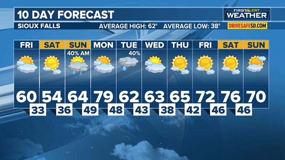
A few showers may linger for areas in southwestern Minnesota early this morning as an upper-level trough exits the area. We’ll see more clouds than sunshine as a cold front moves in from the west. Winds will gradually shift to the north as the front passes. Highs will get into the 50s, but temperatures will fall into the afternoon for places like Aberdeen. Ahead of the front, places like Sioux Falls and Yankton could reach the 60-degree mark.
Tonight the front will sweep through, giving us a partly to mostly cloudy sky. Some models indicate a slight chance of a few light rain or snow showers developing overnight for areas along and east of the James River, but it would be very minor and light if that is the case. Winds will be out of the N at 5-15 mph. Lows drop back into the 20s to near 30.
Saturday will actually turn out to be a rather pleasant day as a wedge of higher pressure will give us sunny to mostly sunny skies. Highs top out in the upper 40s to mid-50s
The chance for rain and snow showers will continue through Sunday morning and gradually end by the noon hour. Skies remain cloudy to mostly cloudy to the east, but some clearing is expected across central and southern South Dakota. Highs will range from the upper 40s to low 50s northeast to the mid to upper 60s south and west.
The warm front will lift across the southern and eastern areas ahead of our next weather system. Models have now shown drier conditions for Tuesday, but there will still be a chance of showers and possibly an isolated thunderstorm or two.

Sioux Falls: Avera Heart Hospital

Sioux Falls: Avera McKennan

Sioux Falls: Downtown

Top 10 Most Valuable College Football Programs
More From KIKN-FM / Kickin' Country 99.1/100.5


